Case Studies
Build Effective Social and Behavior Change Strategies
")
Read More
Nepal has made great strides in improving access to water and sanitation, despite suffering a devastating earthquake and remaining one of the poorest nations in the world. Since 1990, access to improved water sources has increased from 46 to 95 percent. In reality, however, only 25% of the country’s water supply is reported to be fully functional – and of those functioning almost 40% require major repairs. Thus, exacerbating the challenge of increasing access to basic water services for the 3.5 million who are currently without.1 Policy makers worry these challenges will only accumulate as climate instability increases water scarcity, flooding, and other threats to a highly vulnerable country.2
Understanding existing access to improved water, sanitation, and other indicators at the local level is key to targeting underlying challenges. Machine learning allows us to dive deeper into these national level statistics, focusing on the community level nuances that define improved water and sanitation access for people on the ground. Combining the latest remotely sensed data with professionally enumerated household surveys, Fraym technology reveals a varied web of access to improved water sources among communities across Nepal. At the national view, hotspots quickly emerge to draw attention to regions particularly at-risk. At the community view, we can see clusters of households at the square-kilometer level that have particularly acute challenges – and design solutions to address them.
Our heatmap below represents households with access to piped water. Quickly, we note regions to prioritize for investment: for example, Midwest. For an implementing partner operating within the Midwest, resolution becomes particularly important. Zooming below the regional level, communities with varying levels of need and resources become visible. Jumla District overall has low levels of piped water, despite relatively higher levels of access tracing the H13 road and Karnali River to the municipality of Chandannath and domestic airport. This hyperlocal heatmap visualizes trends in water and sanitation access that we may have expected – access surrounding established infrastructure like roads, cities, and airports would be greater than rural areas. Now, Fraym data confirms and quantifies that trend in Nepal.
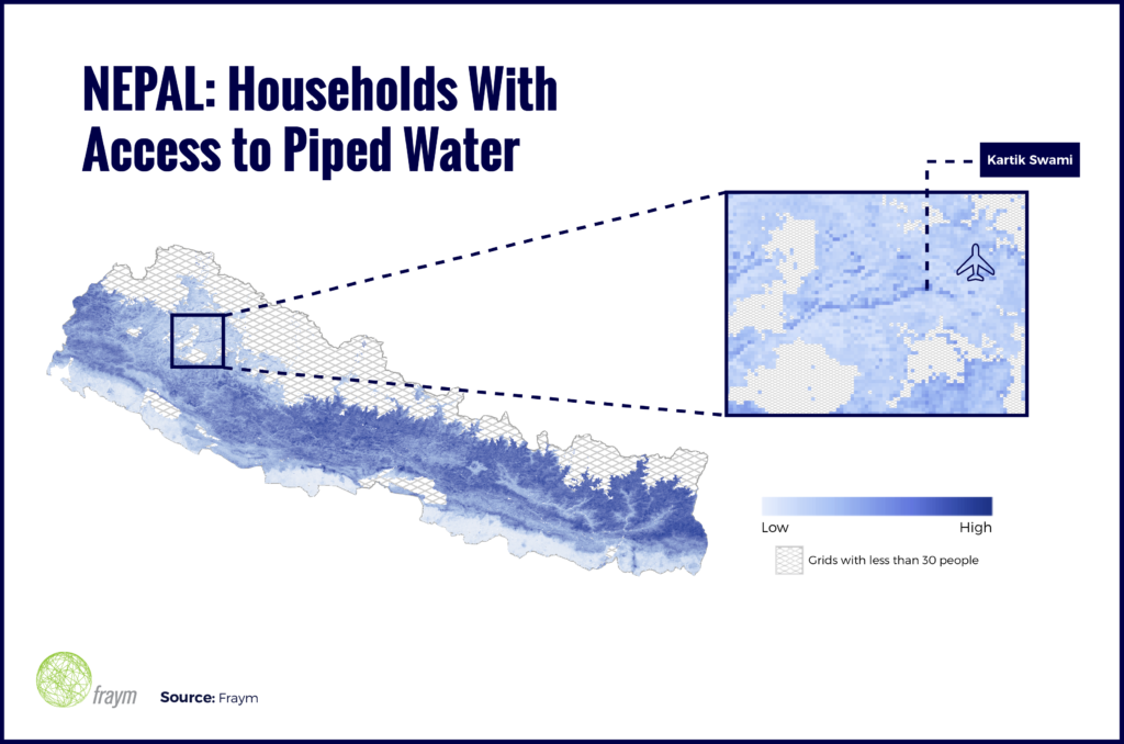
Fraym technology reveals this local-level contrast with unprecedented granularity, all drawing from existing data sources. Expanding access beyond this narrow buffer zone surrounding the river and road would make a targeted difference among more disconnected communities within this region. With this technology, household surveys and aggregate statistics transform into square-kilometer data points – generating information that is useful where it matters, the community and the people our work is intended to reach. For Nepal, improving access to piped water is a community issue, and community level data for decision making will be essential to solving it.

