Case Studies
Build Effective Social and Behavior Change Strategies
")
Read More
Today’s operational constraints to data collection – rising conflict, rapidly spreading communicable diseases, and environmental disasters – can be alleviated with advanced geospatial data. We use machine learning to help organizations understand communities that are difficult to access and have large data gaps. Our algorithms produce a wide range of datasets that cover population characteristics and behaviors. These community-level data are powerful individually, when combined, or as inputs to advanced analytics. This community-level data is powerful individually, when combined, or as inputs to advanced analytics. With this information, our partners can perform reliable baseline assessments that transform monitoring and evaluation over the life of a program.
Baseline Assessment
Description: Fraym’s baseline assessments provide a comprehensive foundation upon which our partners build hyper-local evaluations in previously data-poor environments.
Location: Democratic Republic of the Congo (DRC)
Partner: UK’s the CDC Group
Challenge: Assess the potential social and economic impacts of expanded access to the internet in Kinshasa, DRC prior to implementing a large fiber investment in Africa.
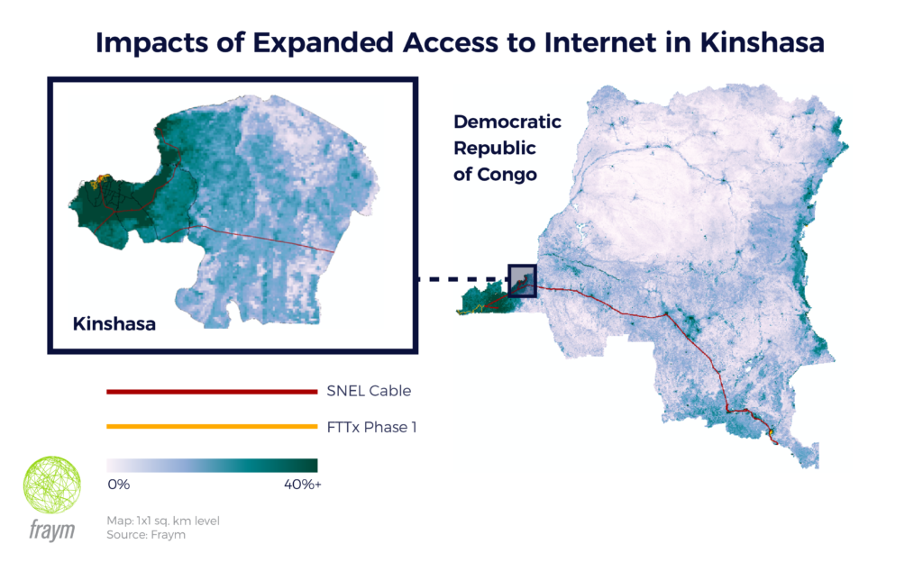
Solution: Fraym delivered a comprehensive baseline assessment of the current conditions related to usage, access, and barriers to internet access in a fraction of the time spent on similar assessments. With minimal primary data collection, we were able to establish current internet access in relation sociodemographic and economic indicators among households and firms along the investment corridor. Our population data layers provided an unprecedented understanding of the baseline conditions, and set the standard for the multi-year monitoring and evaluation efforts surrounding this significant investment.
Multidimensional Contextual Analysis
Description: Pre-existing population data layers can be combined to understand key contextual vulnerabilities that will inform evaluations throughout the life of a project.
Location: Mali and Malawi
Partner: The African Development Bank
Challenge: Produce an index to help understand the human vulnerability to climate change in specific geographies.
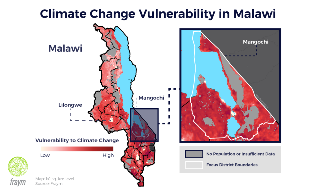
Solution: We used over 20 population indicators across three categories – exposure, sensitivity, and adaptive capacity – to highlight sub-regional trends, outliers, and components of vulnerability to climate change that may affect participant outcomes in any sector. Fraym’s approach to rapidly building such indices now makes it possible to integrate valuable contextual metrics within any evaluation and draw out additional cross-cutting factors that may affect the impact of a program. The initial article about this application was published recently in the African Development Bank’s quarterly evaluation publication, eVALUation Matters.
Both of these approaches leverage pre-existing data sources and remote analysis to provide a robust understanding of the operating environment and contexts that inform monitoring, evaluation and learning plans. Additionally, this newly available data provides discrete inputs into the design of impact evaluations with little to no additional data collection, and without sacrificing accuracy or community-level precision.
