Case Studies
Build Effective Social and Behavior Change Strategies
")
Read More

As the latest flooding in Malawi shows, the country is highly susceptible to climate change and its consequences. With thousands displaced in March 2019, Fraym applied a geospatial analysis of the Malawian population to identify climate vulnerable communities and the issues these communities face. Governments and multilateral actors can pre-empt these consequences by (1) identifying where the most climate vulnerable communities in Malawi are located, and (2) understanding the issues these communities face. In this post, we answer these questions.
In order to tackle the first component, we knew that it was necessary to go beyond individual climate indicators to find vulnerable communities. Instead, Fraym created an index, referencing existing literature on climate vulnerability indices from the Intergovernmental Panel on Climate Change, to measure a community’s vulnerability to shocks. The index is made up of 27 climate-related indicators from Fraym’s comprehensive repository of population, satellite, and remotely sensed data.
The indicators are broken down into three components:
· Exposure: Hazard events, irregular rainfall
· Sensitivity: Agricultural practices, food and water security
· Adaptive capacity: Human, financial, and physical capital
Lastly, we used machine learning to apply the index at a high-resolution (1km^2), to compare different regions within Malawi. Below is a map of the index.
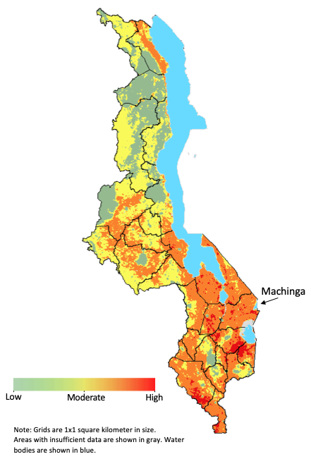
Note: Grids are 1 sq km in size.
Using the Fraym climate vulnerability index, we identified the most vulnerable districts – identified in orange and red. Machinga, located in the southeast, stands out as particularly at risk, with 73 percent of its population living in highly climate vulnerable areas.
Rural communities are of particular importance when considering climate vulnerability, given that these households typically depend on climate-sensitive resources such as agricultural land and rainfall. In Malawi, 90 percent of rural households are agriculture-producing, meaning the household owned or cultivated land. In Machinga, this figure is 97 percent.
Next, we analyzed some of the individual components of the index to better understand households’ resiliency. In terms of exposure, rural households in Machinga are susceptible to negative environmental shocks.
In fact, 89 percent of these households have experienced a shock due to irregular rain and 88 percent have experienced drought, both well above the national averages of 68% and 42% respectively.
Households in Machinga are not only susceptible to shocks, they are ill-positioned to overcome them. A majority of Machinga households, 77 percent, have experienced food insecurity due to drought or poor rains, compared to 51 percent at the national level. This sensitivity and exposure, coupled with a dependency on agriculture, may suggest the need for programming that builds more resilient livelihoods.
Vulnerability, as a result of climate shocks, can be mitigated through adaptive capacity. In Machinga, certain characteristics of rural households may limit their adaptive capacity, including lower literacy rates and less education than national averages. However, in most indicators of adaptability Machinga is comparable to other communities, and some characteristics may well present an opportunity, such as financial capital. For example, 21 percent of households in Machinga have a bank account, which is slightly above the national average.
Indices, like the one discussed above, can be designed to address a variety of challenges including poverty. Tremendous insights around dynamic scenarios – such as conflict – can be gained by combining and analyzing disparate data. The Fraym approach to climate vulnerability offers a tool to aid in resiliency program design and implementation – as well as inform the sequencing of interventions based on individual community needs.

