Case Studies
Build Effective Social and Behavior Change Strategies
")
Read More
At the Global Climate Action Summit governments and organizations will make commitments in response to a series of formal ‘challenges’, which aim to mitigate the effects of climate change. To accomplish their goals they’ll need accurate, local data. In honor of the Summit, we’ve compiled use cases that demonstrate the power of geospatial data in the fight against climate change. Here’s how we’ve helped organizations tackle the kind of problems the Summit is focused on.
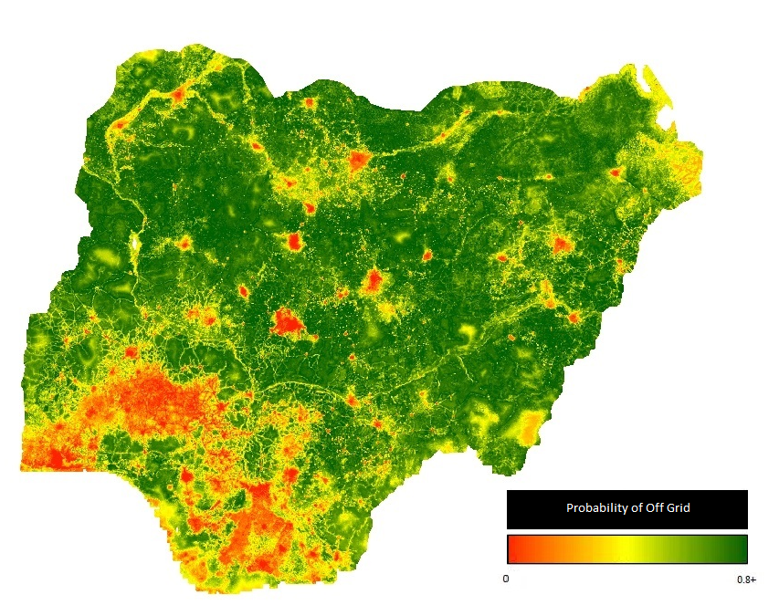
Healthy Energy Systems
Challenge: The Healthy Energy Systems challenge focuses on the global shift toward clean and equitable energy & mobility systems, advances climate progress, and enables healthy people and places.
Insight: By mapping electrification rates, demographic characteristics, and consumption patterns, Fraym has helped multiple organizations identify off-grid communities. Households in these communities now have access to clean, affordable, and equitable energy systems, including solar irrigation and home systems, and micro-grids. In identifying these communities, organizations are better equipped to meet local needs and deliver services directly to those who want them most.Heat Map of Nigeria Showing Electric Connectivity

Inclusive Economic Growth
Challenge: The Inclusive Economic Growth challenge focuses on climate leadership as well as clean technology and energy transitions necessary to generate good jobs, broad-based economic opportunity, and inclusive, resilient growth.
Insight: Fraym worked with the African Development Bank to identify the most vulnerable communities on the continent. By constructing poverty and vulnerability indices, and then using them to inform geospatial models, Fraym was able to produce highly granular surfaces that allow for accurate predictions of poverty and vulnerability. Targeting the most vulnerable communities allows for more inclusive growth programs, leading to more resilient and equitable communities.
Sustainable communities
Challenge: The sustainable communities challenge focuses on building cities, communities, and infrastructure that are clean, healthy and livable.
Insight: Fraym uses environmental, economic, and demographic information to identify sites that would be the most suitable for utility-scale clean energy projects. By creating geospatial layers of off-grid populations, physical terrain, and existing power generation stations, Fraym helped the IFC identify potential sites for a new hydroelectric station in Guinea.
Land and Ocean Stewardship
Challenge: The Land and Ocean Stewardship challenge focuses on acknowledging the role that forests, food, lands, and ocean ecosystems must play in mitigating climate change and making our world more resilient.
Insight: Geospatial data allows us to monitor changes in land use at scale. We can now use satellite images collected over time to track rates of deforestation, measure urbanization, and predict flooding patterns, among other uses. For example, Fraym has leveraged remote sensing techniques to analyze patterns in vegetation, in order to identify the expansion of informal settlements both in major cities and conflict-affected areas.
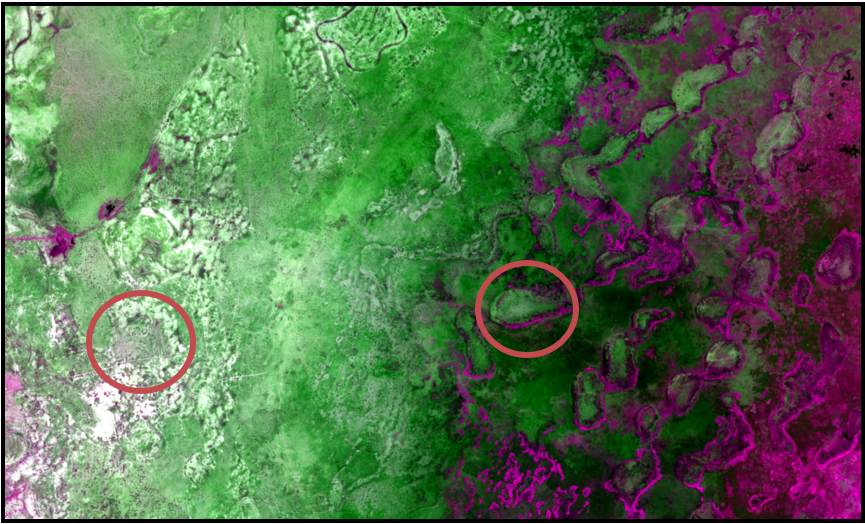
The circular gaps in the purple and green spaces indicate human activity in vegetated spaces. The oval purple signatures are evidence of deforestation.
Combating climate change requires a well-informed strategic approach. Geospatial tools give organizations an edge by helping them better understand humans, the environment and their interactions. Fraym will continue to work with leaders across a variety of sectors to identify the most pressing challenges, build targeted solutions, and monitor progress.

