Case Studies
Build Effective Social and Behavior Change Strategies
")
Read More
As COVID-19 continues to spread around the world, countries in Africa are seeing an uptick in cases with over 6,000 confirmed infections as of April 8. Many global and African health agencies are especially concerned with the continent’s status, warning of low healthcare capacity coupled with an already serious locust plague in East Africa. This past Tuesday, Tanzania announced its first confirmed coronavirus death with the numbers of cases predicted to rise in the coming days and weeks. As many laborers leave cities to return to their villages, the transmission risk of COVID-19 has the potential to become higher.
In response to the pandemic, Fraym has scaled-up data production for countries in Africa, Asia, and Latin America and deployed over 200 hyper-local spatial data layers relevant to organizations and governments fighting the pandemic. In the face of significant unknowns, granular information about at-risk populations is invaluable to those on the front lines in Tanzania and other vulnerable countries.
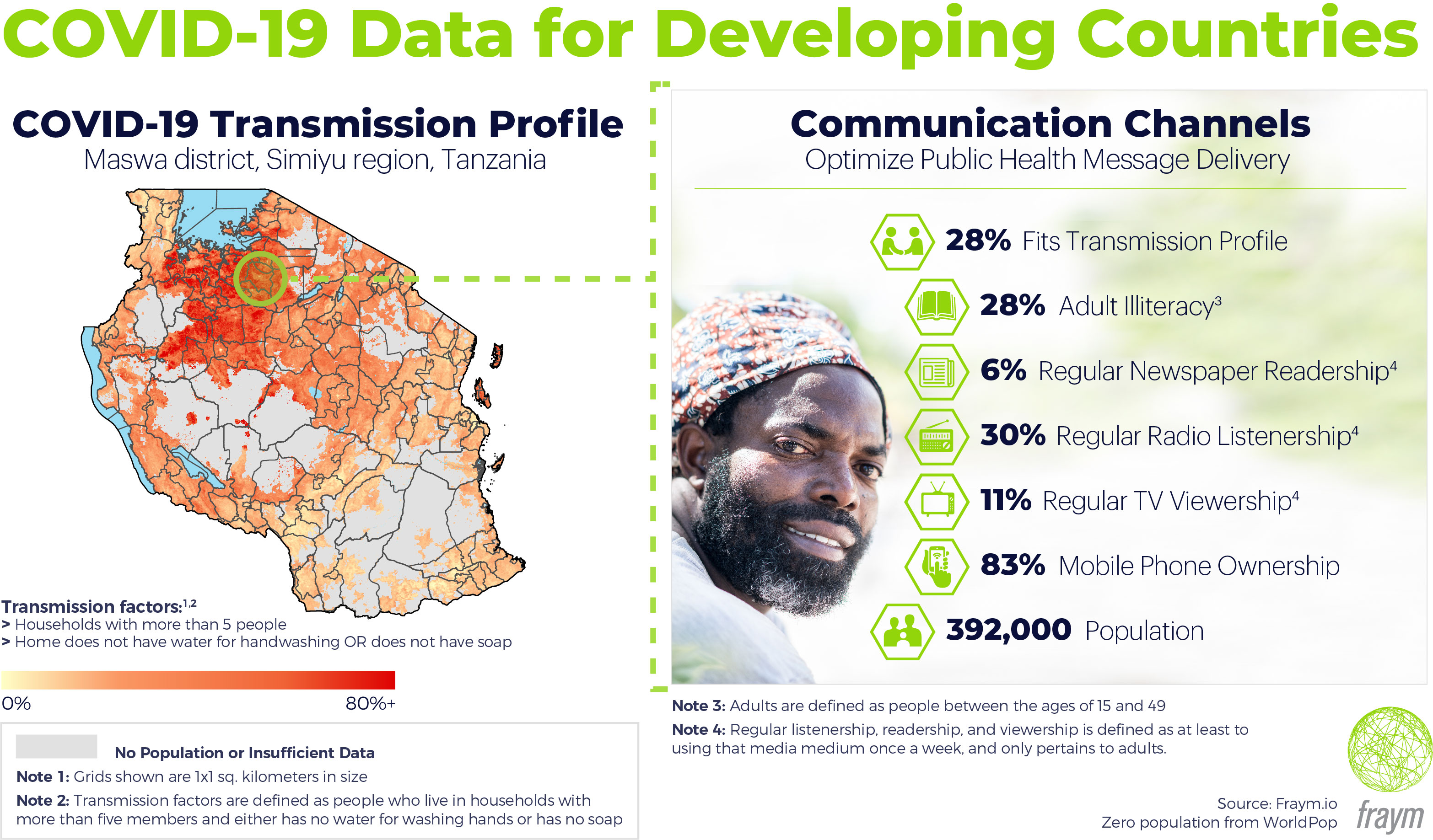
For this analysis, we mapped populations based on a combination of transmission-related factors that include: households with greater than 5 people and homes without soap or without a dedicated place to wash hands. The result is a detailed heatmap showing the geographic concentrations of households with these attributes. Equipped with these insights, healthcare workers, health agencies, and others can quickly understand disparate regions and make decisions based on localized needs.
Once we know where there are concentrations of the transmission profile populations, the effective dissemination of public health information becomes vital. By combining many data sources, including geo-tagged household surveys and remote sensing data, Fraym’s machine learning models can tell us how communities consume news at a hyper local level. Data showing TV viewership, radio listenership, newspaper readership, and mobile phone ownership is now available down to one kilometre squared. This intelligence can be used to select channels for targeted campaigns and to optimize message delivery.
For instance, half of people in the Maswa district in the Simiyu region of Tanzania live in households that fit the transmission profile above. To understand the communication landscape in Maswa, we applied Fraym data on communication channels. Twenty-eight percent of adults are illiterate, which is eight percentage points higher than the average Tanzanian adult. In terms of media consumption, radio is the most popular medium while television viewership is only 11 percent ( twenty percentage points lower than the national average). Despite low levels of media consumption compared to the national averages, radio is the most popular medium in Maswa. Moreover, with 83 percent mobile phone ownership, it could be particularly well suited for voice-based information push campaigns, particularly for reaching those district residents with higher risk profiles.
As the threat of the virus begins its spread across the continent and around the world, spatial information can guide response efforts like health infrastructure deployment, emergency funding allocation, preventative measures, and others. To meet this momentous and tragic crisis, we need to equip ourselves and our teams with data that is specifically tailored to tackle this type of large-scale challenge.

